Historical Images from around 1900
Click on the links below to see a
collection of images from that region.
Franconia Village
The Flume
Sugar Hill #1/2
Sugar Hill #2/2
Cannon and the Tramway
Profile House
Profile House
Profile House (Dining Room & Menus)
Profile House Rules for Waitresses
Profile & Franconia Notch Railway
Profile Golf Club History
1899 Golf Bulletin Article on
Courses in the White Mountains
History of Sugar Hill
See also Notes on the Images
A Brief History of Franconia Notch & the Profile House
Thirty-five 35 years after the discovery of the White Mountain Notch (now Crawford Notch), the road
survey crew of Luke Brooks and Francis Whitcomb found the Great Stone Face (Old Man of the Mountain) on the side of Frank Mountain in Franconia Notch in 1805. (In 1917 Frank Mountain was officially renamed Profile Mountain, and in 1972 it was renamed Cannon Mountain.)
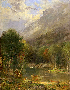
1886 Painting by Samuel Lancaster Gerry (1813-1891)
The way through Franconia Notch was an old Native American trail, which eventually came to be called the Franconia Road. After the Franconia Township was granted in 1754, the first settlers arrived on foot, horseback, and oxcart, following the trail through a virgin wilderness, said to be so thick that few views of the mountains could be seen. As more settlers arrived, the blazed trail became a rough wagon route that, by 1800, had become the major link with other parts of New England.
In 1805, the state hired Enoch Colby to lay out a road between Franconia and Peeling (now Woodstock) and Colby in turn hired Nathaniel Hall of Thornton. In 1813, the rough survey line was cleared of trees, stumps, and rocks, and the first road was constructed. At first it was a toll road, called the Pemigewasset Turnpike. A man on horseback paid one cent per mile; a two-wheeled cart, one and a half cents per mile; a drove of ten cattle, two cents per mile. Mail was being carried by horseback at six cents per mile.
- from The Franconia Gateway by Bruce D. Heald, Arcadia Publishing, 2003.
This 1833 map of the region shows a road through the Notch, but it was not a stage route. (The lines that look like railroads are really roads with stage routes: railroads were not built in 1833.) One can only imagine how difficult the road from Plymouth to Franconia must have been at this time! Map making in 1883 wasn't as precise as today, and some of the features are clearly misplaced, but one can see Profile Lake (next to the legend Frank Mt) as the source of the Pemigewasset River. There's an east-west stage route from Carroll to Littleton, and another north-south route from Littleton to Lisbon and south. (Click on the map below to enlarge it.)
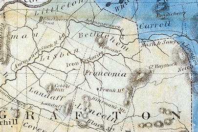
1833 Map of Roads and Stage Routes by J.R. Goodno (click image to enlarge it)
The first visitors to Franconia Notch came from the south, via steamers on Lake Winnipesaukee and by rail to
Plymouth and later North Woodstock. The trip took more than one day and substantial hotels appeared at the
railroad junctions. This lovely 1860 engraving image shows the Pemigewasset House in Plymouth on the Boston,
Concord and Montreal Railraod.
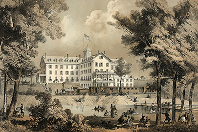
1860 Handcolored Engraving of the Pemigewasset House by J.H.Bufford
Early tourists ventured north, first to Campton, and then on to Woodstock. Lincoln and North Woodstock were
'dirty' logging towns and there was little tourist interest. The vista of Franconia Notch from Campton became
known as the "Artist's View" and many paintings and photographs were produced from here. This 1883 painting
by George Albert Frost gives the classic view of the Notch from the south.
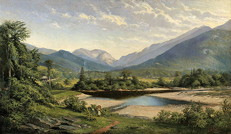
1883 Painting by George Albert Frost (1843-1907)
Construction began on the Profile House in 1852 by Richard Taft and Charles Greenleaf, owners of the Flume
and Franconia Hotel Company. It was a simple three and a half story building at the start. That same year,
the White Mountains Railroad reached Lisbon and Littleton (from Woodsville).
Taft and Greenleaf bought the Lafayette House (then situated near present-day Lafayette Campground) and moved
it north near the Profile House to house the staff. The Profile house was expanded numerous times, a west
wing was added, then an east wing, a large dining room and numerous outbuildings including a stable that
eventually housed 350 horses and an impressive collection of wagons and coaches.
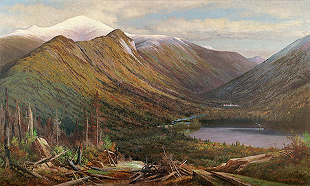
1887 Painting by Profile House Artist-in-Residence Edward Hill (1843-1923)
In 1868, cottages were added, growing to 20 in number. The cottages were large, some with as many as 20
rooms. They were connected to the main building by covered walkways to provide safe passage to dinner during
inclement weather. Most were privately owned by families who came for the summer and wanted more privacy than
the hotel could offer.
The hotel offered every convenience that city dwellers were accustomed to: boathouses on Echo and Profile
Lakes to store boats, a bowling alley, post office, telegraph office, barbershop, billiard hall, resident
small orchestra, a golf course and more. There was a fish hatchery on a small trout pond just south of the
hotel, used to stock Echo and Profile lakes.
With a capacity of some 500 guests and 400 staff, the hotel operated a large farm with herds of cows, a large
greenhouse to grow vegetables. An on-site power plant provided electricity, and a nearby mineral spring (near
Boise Rock) provided water.
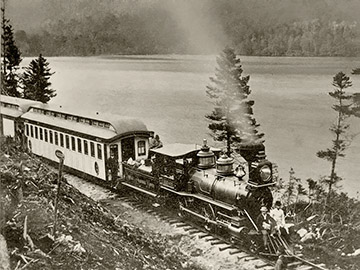
1880 Photograph of Echo (Engine #1) along Echo Lake in Franconia Notch
by Benjamin W. Kilburn (1827-1909)
The last leg of the journey to the Profile House was long and hard on stagecoaches from either Littleton or
North Woodstock. When the Gale River Lumber Company ceased operations in 1878, Taft and Greenleaf saw an
opportunity to build the Profile & Franconia Notch Railroad (narrow gauge) from Pierce Bridge in
Bethlehem to the Profile House and Flume House. Passengers could then connect to the Boston, Concord and
Montreal line and avoid the stagecoach trip. The 9.46-mile railroad followed the route of the Gale River
Logging Railroad for several miles and then continued into the Notch. (The section to the Flume House was
never built.) The P&FN Railroad opened with an elegant little station at the Profile House in June of
1879. There was a passenger shelter at the Profile Golf Links and a wye track at both ends of the line for
turning engines.
At Pierce Bridge, the P&FN built a covered bridge over the Ammonoosuc to bring their narrow gauge trains
over the river to meet standard gauge BC&M trains on the north bank, and to facilitate transfer of
passengers, baggage and freight. This connection was named Bethlehem Junction. Two narrow gauge, wood
burning, locomotives, Echo and Profile, were bought to provide service between Bethlehem Junction and the
Profile House.
Two years later, the P&FN extended its line west from Bethlehem Junction to serve the Maplewood and other
hotels along Bethlehem Street. This 3.38 mile branch extended to Park Avenue in Bethlehem, with an
intermediate station at the Maplewood Hotel, and opened in July 1881. This necessitated purchasing a third
locomotive, known as Bethlehem, and additional passenger cars. Passengers from Boston had to make two changes
(Fabyan House and Bethlehem Junction) to reach the Profile House. Boston, Concord and Montreal eventually
bought the P&FN narrow gauge line and extended it 6 miles east to Zealand, reducing the number of
transfers to one.
The Profile House was such a success, that at the end of the 1905 season (the hotel was only open for the
summer months) the hotel was demolished and the New Profile House built. The new hotel had 200 guest rooms
and a new dining room. The cottages were not disturbed.
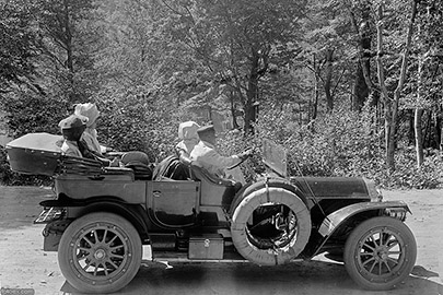
Car of Tourists in Franconia Notch, by Detroit Publishing Co., 1912
With the age of the automobile arriving in the mid-teens (c. 1915), a motor entrance and 200-car garage were
added. In 1921 the railroad ceased operations because of the success of the automobile, and in August, 1923 a
devastating fire destroyed the Profile House and Cottages. Because all the cottages were connected by covered
walkways, they, too were destroyed. The garage contained some 800 gallons of gasoline and made a spectacular
explosion. The owners originally planned to rebuild, but never did. The land they owned became the Franconia
Notch State Park.